The wife asked, "Why would you want to go to your 50th high school reunion?"
To see how it all turned out, that's why.
| When I reached the
Springfield/Branson airport, the girl at the car rental
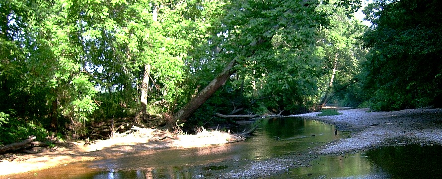
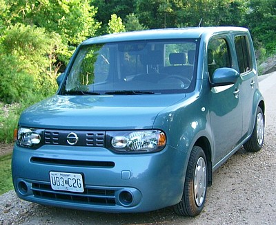
counter said, "I've got a turquoise cube for you." "Fine," I said. I wondered, "What the hell is a Turquoise cube? who makes a line of sub-compact cars call Turquoise?" Well I found out. It was A Nissan Cube, turquoise in color. Needless to say I turned some heads in that little farming town full of pickup trucks. I loaded the bags into the Cube and headed east on US 60. My first stop was the cemetery in Hartville, where my best teacher and friend, and her husband are buried. Then I scooted east on State 38 which parallels the Gasconade River for the first few miles. I noticed they'd built a new public access and investigated. The family that was swimming in the pool told me the water was down a little and they could wade all the way across the pool at it's deepest part. They also suggested the best fishing was about 100 yards down stream. "Big Bass. Next stop was the Baptist Church Camp where "38" crosses Whetstone Creek. There was plenty of water in Whetstone. |
  |
|||||
| I headed north on Farm to Market E at the Baptist Church Camp and drove about two miles, to the place where "E" crosses the Gasconade. I noticed they'd replaced the bridge that my Grandfather had built back in the ‘50s. It was the last concrete work he did. The new bridge didn't look much different that his, and I noticed that drift was piling up on the upstream side, just like the old bridge. The state still hasn't taken down the "Impassable during high water" signs and the water depth signs. The water looked good. From there I followed "38" east, across State road 95 to the bottom of the hill and Beaver Creek. Beaver looked good, too. But the access around the bridge was choked with vegetation, including, I guessed, Poison Ivy. Not something I wanted to mess with on this trip. Dad had always stayed to the state roads but I didn't have to do that. I headed south on "95" and took the first county road that went east to Beaver. I found a nice low water crossing with plenty of stream access. I figured it was time to head for home (or what had been home.) Coming into town from the north on "95" I stopped at the cemetery to see the family. Mom, Dad, Both sets of Grandparents, a Great Uncle and his wife, Aunts and Uncles, Cousin Bob and his wife. Also among the headstones were the family friends. Names from my childhood. All here. All neatly in rows. I suddenly realized that I knew more people in the cemetery than I did in the town. My generation was scattered to the four winds. Not many of us stayed, or came back. After check in at the no-tell motel and a wonderful meal at Mickey D's, I still had daylight and no place to go... except to do more exploring. Farm to Market N parallels the new US 60 west for a few miles. Then the two leave each other and "N" follows Archer Creek, (Which is referred to as the east branch of Whetstone creek in the DeLorime). I followed the water for several miles before the stream and road parted. From there it was only a few miles to the bridge over Whetstone, proper. A farm road lead off to the left and an open gate and path lead down to the water. I was more interested in the farm road, which I believed would lead to a low water bridge across the Whetstone. I was right. I also saw a doe in one of the fields. By this time I was driving with headlight in the gathering gloom so I turned the Cube around headed back to town, passing the deer, still standing in the field. My next stop was the ubiquitous "Wally world" for a license. Missouri has my name. I guess I'm on some kind of a watch list or something. They've done away with three or five day out of state licenses. Now you pay by the day or the year. I paid by the day and got my bright yellow tag. I was fairly sure I'd not need it, but I have been "carded" once in Missouri. It was during deer season and Marge and I were headed across from Hartville to Rolla and stopped by Dog Bluff, to check it out. I pulled into the public stream access and pick-nick area and strung up a rod. Marge found a kitten wandering around about the time Missouri Fish and Game showed up. She was trying to get him interested in the kitten, but he was looking at me. Luckily I'd just stopped at liquor store in Hartville so I was able to show him the yellow slip. "I got tired of checking deer tags," he said, smiling at me. I smiled back. On his recommendation we took the little kitten into Houston and dropped it off at an animal rescue. Yes they have those in Missouri. The next morning I got up at 6:00 am, which is when the "No-Tell" free breakfast opened. Apparently the Indian didn't believe in overdoing breakfast. (or he was putting out as little as he could and still be able to claim a free breakfast.) I headed north with the idea of eventually ending up at the Casconade. I headed up "N" and found a side road that went south over Archer Creek. I pulled the Cube to the side of the road, rigged a 3 piece 6 1/2 ft rod and slipped into the 4 inch deep water. The topography in the Ozarks is fairly flat. The rolling hills have been cut away by weather and water since long before the Indian came. The streams flow over flat stone, gravel or sand. They're magical, because they can be a flat trickle of water only 4 or five inches deep for miles, then suddenly turn into some very nice fishing pools. I know that Archer Creek holds good sunfish -- I'll get to that, but on this stretch of the creek the 4in 15ft wide went on and on. Eventually I gave up trying to ease down stream and pick up a fish before it knew I was around. |
||||||
| Back at the Cub, I stuck the rod in across the back seat, pulled off the wading shoes and replaced them with my boat shoes.Next stop was Whetstone, at the low water bridge. I pulled the Cube off the road into the side of the entrance to a field, rigged up and started prospecting. Unlike trips of the past, I was into fish almost as soon as I got in the water. The stream was about 20 feet wide and less than three feet deep except for holes around the root wads. A heat wave allowed me to wet wade. The water was cool but not cold. I was using the 6 ½ ft, three piece, four weight. (All my rods fit in my luggage. I really don't want to spend $50 a rod on baggage.) I wandered down the creek casting to the far bank. Several trucks and a car crossed the bridge while I was working my way down stream. I noticed that each one of them slowed to a crawl as they crossed. At first I though it might be to see if the idiot driving the turquoise Cube was catching anything, but then I realized it was because the bridge (that I'd crossed the night before) was about to give way. Had Hector been with me I'm sure we would have been pushing the Cube out of the creek!!! I can't remember how long I fished Whetstone below the low water bridge, but eventually I hit an area that was wide and shallow and didn't look promising. I had other waters to explore, so I headed back up stream. I had a few more | 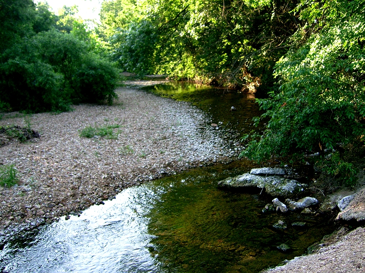 |
|||||
| fish on the way back to the
car, but not as many as down stream. I'm sure my wading
had a lot to do with that. |
||||||